
Satellite cloud images help you understand the weather: Do you know what convective clouds look like?
|
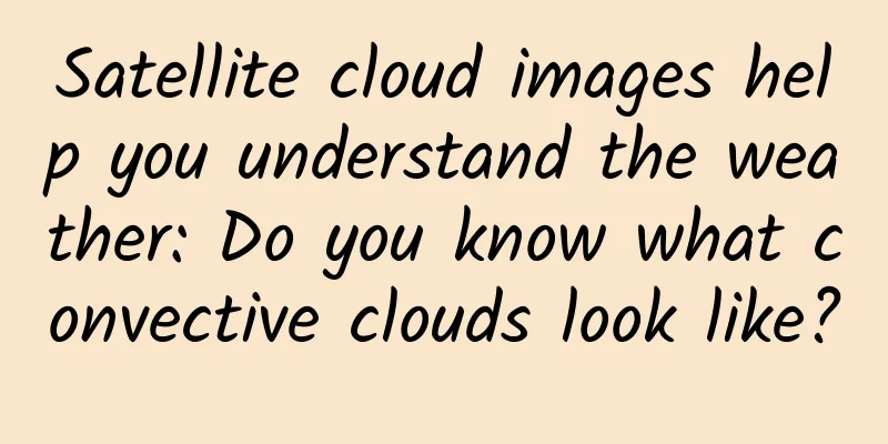
Small convective cloud Convective clouds are clouds formed by convection. When the atmosphere is in an unstable state, with cold air on top and warm air on the bottom, the warm air in the lower layer will rise, thus forming convection. The temperature of the rising warm air will continue to decrease, and when it reaches a certain height (condensation height), water vapor will condense to form clouds. This type of cloud is a convective cloud. If the convective clouds are distributed in clusters, they are called convective cloud clusters. Arrows point to small convective clouds. What should I do if I see convective clouds? If the convective clouds are scattered, you don't need to pay too much attention to them. If the convective clouds gradually gather and increase in number, you need to pay attention, because severe convective weather may be coming! Heavy precipitation may occur. fog Want to know how to tell whether it is fog or cloud from satellite cloud images? First of all, we need to understand what fog is. Fog is a liquid weather phenomenon composed of tiny water droplets or ice crystals suspended in the air near the ground. It is the product of condensation (or sublimation) of water vapor in the air near the ground. Fog has obvious daily changes. The temperature is relatively high during the day, and the air can hold more water vapor. However, at night, the temperature drops, and the air's ability to hold water vapor decreases. Therefore, some of the water vapor will condense into fog. Fog is usually most likely to appear from midnight to early morning, and will quickly dissipate after sunrise. The arrow points to the "branch-like" mountain fog. What should I do if I see fog? Pay attention to whether there are any warning signals in the local area, and drive slowly when visibility is low. Wave Cloud System Wave clouds are orographic clouds formed in air currents crossing hills or mountains. They are several kilometers to tens of kilometers long and present light and dark, neatly arranged parallel cloud bands, like ripples. This is caused by the vertical fluctuations of the atmosphere, the wind direction is orthogonal to the mountain ridge, the atmospheric stratification is stable, and the cloud bands are parallel to the mountain ridge. The picture shows a wavy cloud system. What should I do if I see wavy clouds? This type of cloud system will not produce any violent weather processes, it just has a special shape. |
<<: 60 times the limit! Well-known yogurt was investigated... How to choose yogurt?
>>: How do colored diamonds come about? They lose color after being polished!


Recommend
Warcraft Movie: The Sunset of a Legendary IP
(Original title: Warcraft Movie: The Sunset of a ...
In-depth analysis! Understand the massive amount of Qianchuan delivery techniques in one article!
From the underlying algorithm of the launch, brea...
How to establish effective promotion channels for university marketing?
University marketing is mainly targeted at studen...
The new energy vehicle industry has entered the most stringent regulatory period, and there is zero tolerance for fraudulent subsidies
In early 2016, the General Offices of the Ministr...
After leading Real Madrid to win the Champions League, can Ronaldo help Nubia win the "derby"?
The 2016 UEFA Champions League has come to an end...
Five motivations for users to follow TikTok
How can you attract Douyin users and become an in...
What "gem" made the pigment artist go to Ailao Mountain alone? Experts: Not suitable for pigment making
"A small blue mineral, very beautiful... a s...
How to do membership marketing well? 6 key points!
Taobao 's 88v ip membership, annual passes fo...
Experts: Windows Phone is the most secure mobile system
[[155337]] Although Microsoft's Windows Phone...
I am having a great time traveling, but why are there always these cunning bugs trying to harm me?
It is inevitable to encounter various kinds of in...
Is the central bank's "suspension order" useless? WeChat is pushing QR code payment again
Recently, after WeChat updated to version 1, it a...
One article to understand the construction of community operation system
This article uses the 5w1h analysis method to int...
Brand marketing innovation theory!
How to create such a Tribe "new community&qu...
Behind the Remix OS hardware carnival: Which is more promising, upgrading monitors or making game consoles?
It has been a long time since I have seen a manuf...
The ancient tomb has been underground for thousands of years. Will the mechanism inside rust? The ancients thought of this long ago.
Previously, film, television and novel works abou...