
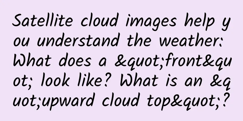
Satellite cloud images help you understand the weather: What does a "front" look like? What is an "upward cloud top"?
|
Front Does the term “front” look very professional? In fact, it is the interface or transition zone between two air masses with different physical properties such as temperature and humidity. In simple terms, it is the interface between cold and warm air masses. The intersection of the front and the ground is called the front line, or simply the front. The length of a front can generally range from several hundred kilometers to several thousand kilometers, and can extend more than ten kilometers in the vertical direction. According to the thermodynamic classification method, if a cold air mass pushes a warm air mass forward, it is called a cold front; otherwise, it is a warm front. If the cold and warm air masses are of equal strength, it is called a quasi-stationary front. If a cold front catches up with a warm front, an occluded front will form. Without further ado, maybe you will understand it by combining it with satellite cloud images! The arrow in the figure points to the cold front. What should I do if I see a cold front? In winter, the cold front is strong and brings cold waves; in summer, the cold wind is weak and brings thunderstorms. Attention! When a cold front passes through, the temperature difference between two places in the same province can reach more than ten degrees. Remember to add or remove clothes appropriately! Up to the top As a characteristic of severe storms, upthrust cloud tops are associated with updrafts that clearly penetrate the equilibrium altitude (i.e., the altitude of the broad thunderstorm cloud tops). In the visible light cloud images of Fengyun satellites, upthrust cloud tops appear as bright bulges, like "little bumps". Bright bulges above the cloud tops can be seen at locations A, B, and C in the picture. What should I do if I see the sky heading up to the top of the clouds? The appearance of upthrust cloud tops indicates the presence of strong updrafts in the area and a high likelihood of severe weather. Roller Cloud Also known as wave clouds, they are horizontal, tube-shaped clouds. Wave clouds are created when stable air is disturbed, causing the air to move along the disturbance, like waves in a pond. This disturbance is usually created when cold, dry air from a moving cold front collides with a relatively stable area of warm, moist air. If the stable layer of air is moist, clouds form on top as the air flows upward. When the air flows downward, the clouds evaporate. The alternating absence and presence of clouds is what creates the wave effect. (Photo/Text by Jia Xu and Xie Yifei) The arrow in the picture points to the roller cloud. This type of cloud system mainly occurs over the sea and may indicate that a squall line or thunderstorm is approaching. Once you see it, please return to a safe place in time to be on the safe side. |
<<: 167 flights a year! This professor's belief ignites countless people
>>: Infected and in quarantine? Keep this list of items to keep!


Recommend
How to build an Android MVVM application
1. Overview Databinding is a framework, MVVM is a...
Digging the root | Will having intimate relations with an AIDS patient definitely lead to infection? Can you donate blood when HIV is not detected in the blood?
gossip The pathogen of AIDS is HIV (human immunod...
Tesla is caught in the "reduction in configuration" scandal: speed is the key to success and speed is also the key to failure!
Perhaps it is due to the founder's personalit...
Mobidev: Top 3 Fintech Trends in 2022
As one of the most disruptive industries, FinTech...
These 5 most common household items are actually extremely dirty (the fourth one is used by everyone)
Everyone has different habits when it comes to cl...
A brief history of glasses: What did the ancients do if they were nearsighted?
Zhao Xigu of the Southern Song Dynasty wrote in h...
Short video APP product analysis report!
The structural framework of this article is shown...
This is how products with over 100 million users retain users
The content of this article is a summary after ac...
Product analysis of Kuaishou, Douyin and Weishi!
The article conducts a comparative analysis of th...
Are foods highly toxic after they sprout? Some foods can cause poisoning, while others have doubled nutritional value...
This article was reviewed by Liu Shaowei, food sa...
Zhao Rui: A Practical Guide to WeChat Marketing Management for Enterprises
Zhao Rui: A Practical Guide to Enterprise WeChat ...
Elderly care robots are here! They can make tea, feed cats, practice Wing Chun, play the piano, flip the spoon and play mahjong
Author Li Chuanfu Elderly care robots are here! S...
Why is the water conservancy project from 2,300 years ago still in use today? The principle of Dujiangyan is amazing
If you were asked to quickly name two famous wate...
Introduction to the advantages of 360 search advertising promotion!
Search Ads Search promotion is a marketing produc...